Project description
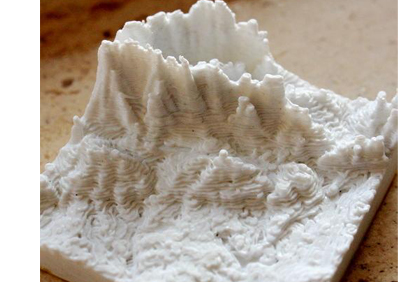
Piece of Earth allows users to easily print 3D models of topographic data by selecting an area of interest from a map and configuring some basic parameters (print size and quality). The application automatically acquires and processes the relevant data and converts it into a 3D model, ready to be printed.
FIWARE technology makes this possible, providing the tools to manage of all the geographic information, allowing users to collaborate by adding datasets, as well as allowing to preview the final 3D product from the browser. The goal is to help users visualize topographic information in a real object, which can be of use to the general public (decoration, hike planning, etc.), specialized businesses (architecture and engineering) or the education sector (geography, history recreation, museums, etc.).
.
Piece of Earth
Crowd-sourced and Cloud-based Design & Services for 3D Printing